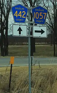
Douglas County, Kansas, maintains an extensive network of county highways to serve the rural areas and state parks of the county. It is one of a handful of Kansas counties to do so.
The major county highways are set up on a grid. East–west-oriented roads have a three-digit number beginning with the numeral "4" and ending in an even digit. The further north the road, the lower the number; the further south, the higher the number. North–south-oriented roads have a four-digit number beginning with "10" and ending in an odd digit. The further west the road, the lower the number; the further east, the higher the number.
There are also minor county roads with one or two digits that travel a short distance or serve a state park.
None of the county highways enters Lawrence, the county seat.
The maximum speed limit on all county highways in Douglas County is 55 mph (89 km/h).
Lists
Major east–west oriented roads
| Highway | Western terminus | Eastern terminus | Notes |
|---|---|---|---|
| Lawrence city limits a half mile north of the intersection of Kasold Drive and Peterson Road | Part of the "Farmer's Turnpike" between Lawrence and Lecompton | ||
| Shawnee County line; road continues as SE 45th Street | Known to locals as "Stull Road" as it passes through Stull | ||
| Intersection of Noria Road/East 1750 Road near the East Hills Business Park | Johnson County line; road continues as W. 103rd Street en route to DeSoto | Former alignment of K-10 | |
| Shawnee County Line; road continues as SE 89th Street | Johnson County Line; road continues as W. 150th Street en route to Olathe. | ||
| Osage County Line; road continues as E. 133rd Street | Johnson County Line; road continues as W. 159th Street | ||
| This highway runs along the Douglas-Franklin County Line |
Major north–south oriented roads
| Highway | Southern terminus | Northern terminus | Notes |
|---|---|---|---|
| Franklin County Line; road continues as Florida Terrace | |||
| Jefferson County Line; road continues across Kansas River as Lecompton Road en route to Perry | |||
| Franklin County Line | |||
| Franklin County Line | |||
| Jefferson County line; road continues north to McLouth | |||
| Franklin County Line, road continues as Old Highway 59 | Former alignment of US-59. | ||
| Franklin County Line 3 mi. south of Baldwin City; road continues as Ohio Road. | |||
| Franklin County line; road continues as Vermont Road en route to becoming 1st Street in Wellsville | Leavenworth County line at Kansas River north of Eudora; road continues as Leavenworth County Highway 1 en route to a junction with the Kansas Turnpike and Tonganoxie |
Minor county highways
| Highway | Western or Southern terminus | Eastern or Northern terminus | Notes |
|---|---|---|---|
| Lone Star Lake | |||
| West side of Clinton Lake | |||
| North side of Clinton | |||
| Clinton cemetery | |||
| N 200 Road and E 750 Road | |||
| In Clinton | |||
| In Lake View | |||
| In North Lawrence, continues as North 7th Street. | |||
| High Street / Lawrence Street in Baldwin City | Part of original route of US-50 | ||
| NW side of Douglas County Lake | |||
| High Street / First Street in Baldwin City | Part of original route of US-50 |
See also
References
- "Douglas County, Kansas Roadmap" (PDF). Douglas County, KS: Douglas County, Kansas. Retrieved October 10, 2019.