Monestier-du-Percy | |
|---|---|
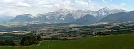 A general view of Monestier-du-Percy | |
Location of Monestier-du-Percy | |
 Monestier-du-Percy  Monestier-du-Percy | |
| Coordinates: 44°47′42″N 5°39′34″E / 44.795°N 5.6594°E | |
| Country | France |
| Region | Auvergne-Rhône-Alpes |
| Department | Isère |
| Arrondissement | Grenoble |
| Canton | Matheysine-Trièves |
| Government | |
| • Mayor (2020–2026) | Robert Cuchet[1] |
| Area 1 | 15 km2 (6 sq mi) |
| Population | 248 |
| • Density | 17/km2 (43/sq mi) |
| Time zone | UTC+01:00 (CET) |
| • Summer (DST) | UTC+02:00 (CEST) |
| INSEE/Postal code | 38243 /38930 |
| Elevation | 597–1,896 m (1,959–6,220 ft) (avg. 804 m or 2,638 ft) |
| 1 French Land Register data, which excludes lakes, ponds, glaciers > 1 km2 (0.386 sq mi or 247 acres) and river estuaries. | |
Monestier-du-Percy (French pronunciation: [mɔnɛstje dy pɛʁsi], known as Le Monestier-du-Percy until 31 December 2022[3]) is a commune in the Isère department in southeastern France.[4]
Population
| Year | Pop. | ±% p.a. |
|---|---|---|
| 1968 | 181 | — |
| 1975 | 153 | −2.37% |
| 1982 | 146 | −0.67% |
| 1990 | 166 | +1.62% |
| 1999 | 166 | +0.00% |
| 2009 | 230 | +3.31% |
| 2014 | 247 | +1.44% |
| 2020 | 247 | +0.00% |
| Source: INSEE[5] | ||
See also
References
- ↑ "Répertoire national des élus: les maires". data.gouv.fr, Plateforme ouverte des données publiques françaises (in French). 9 August 2021.
- ↑ "Populations légales 2021". The National Institute of Statistics and Economic Studies. 28 December 2023.
- ↑ "Décret n° 2022-1739 du 27 décembre 2022 portant changement du nom de communes", Légifrance (in French), 27 December 2022, retrieved 4 October 2023
- ↑ INSEE commune file
- ↑ Population en historique depuis 1968, INSEE
Wikimedia Commons has media related to Monestier-du-Percy.
This article is issued from Wikipedia. The text is licensed under Creative Commons - Attribution - Sharealike. Additional terms may apply for the media files.