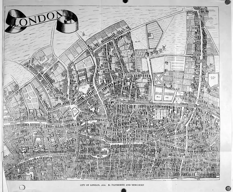
FAITHORNE AND NEWCOURT
Description.—This map generally goes by the name of Faithorne, the engraver, but in reality the credit is due quite as much to Richard Newcourt the elder (d. 1679), who was the draughtsman. It is selected for a place here because, the date being 1658, it shows the City as it was before the Fire, and therefore forms a supplement to the map of Ogilby which follows, and shows the City as it was when rebuilt after the Fire.
Engraver.—William Faithorne the elder was born in 1616, and was an engraver and portrait painter. He engraved numerous portraits, book-plates, maps, and title-pages. Among his works are two large maps, entitled "Cities of London and Westminster," and of "Virginia and Maryland."
Original.—The only two copies of the original issue known to be extant are in the Print Rooms, British Museum, and in the Bibliothèque Nationale of Paris. The map here given is taken from a sheet of that in the British Museum, and is on the same scale.
Details.—It will be noticed that the sheet chosen for inclusion in this atlas shows very nearly the same area as the map of Ogilby which follows, but does not go quite so far eastward as the Tower. The City wall is clearly shown along the north side of the City, and the bastion near Cripplegate stands out; the town ditch can be traced just beyond this corner running southward. It was the curious and apparently meaningless angle that the wall makes here which led Sir Walter Besant to suggest that it may have been designed to exclude the ancient Roman amphitheatre, of which the site is now lost (see Early London, p. 85). The Fleet River is shown still open and crossed by bridges, of which there are no fewer than five from Holborn to the mouth. That at Fleet Street shows, indeed, a continuous line of houses. St. Paul's is very clearly delineated. The figures within the City refer to the old churches, of which a list is given below. Notice the gable roofs, still the chief style of domestic architecture. The lines of the streets in the heart of the City remain wonderfully the same to our own day. Outside the walls the City is stretching out great arms into the country. There is one such arm made by the continuous houses fringing Bishopsgate Street as far as the extreme northern limit of the map. Then there is a gap between this and Moorgate Street, including all the ground known at Moorfields and Finsbury. A few scattered houses and some cultivated fields cover this space, and in one corner is "Bedlame."
A mass of houses lies westward, running on to the Charter House, northward of which are open fields, and so to "Clarkin Well."
The Severall Chvrches within the Walles of London Distinguished by seuerall Figures, By which allsoe the Eye may partly be guided to the Eminent Streets in or neere which they stand, which could not well be otherwise demonstrated, in regard of the small Scale by which this Mapp is described.
|
1. Albans in Woodstreet |
33. Gabriell in Fanshawes streete 34. Georges in Bottolph lane |
68. Martins Orgars nere Eastcheape 69. Martins Outwitch next Bishopsgate stret |