Ilgaz National Park
Ilgaz National Park (Turkish: Ilgaz Milli Parkı) is a mountainous area in the Western Karadeniz region of Turkey. Ilgaz ski resort is 310 km northeast of Ankara, so it's within a day-trip from the capital.
Understand
- Ilgaz Anadolu'nun, Sen yüce bir dağısın / Baharda yer yüzünde, O cennetin bağısın . . .
They may have only a vague notion of its whereabouts, but every Turk recalls singing at school that "Ilgaz, thou art a sublime mountain of Anatolia; on earth in spring the garden of heaven . . . " They were continuing a tradition of wild exaggeration started by the ancient Greeks, who called it Ὄλγασσυς (Olgassys), a soaring unscalable mountain. Its summit at Hacettepe is only 2587 m above sea level, so frankly it's no great challenge to anyone more sensibly attired than sandals and toga.
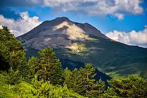
The Ilgaz range is part of the Pontic Mountains which rear up behind the Black Sea's south coast, from Marmara in the west to Georgia in the east. These are the product of two long fault lines, which continue to shift and roil the region. Their height means they draw the cloud and rain, falling as snow in winter, and this waters a dark band of spruce forest. The dusty plains and hills of Anatolia to the south are in the "rain shadow", relatively dry, so the contrast as you approach is stark.
The climate is typically alpine, with mild summers and very cold winters. Snow can linger well into summer. The terrain is suitable for forestry and small-scale hill farming, but there's little flat land for arable farming, and no ores to attract mining and associated industry. Its forests have been little disturbed and are home to bears, wolves and eagles. A section of Ilgaz was declared a national park in 1976, while other areas are tourist resorts.
Get in
Mount Ilgaz is above highway D765, which runs north from Ankara via Çankırı and Ilgaz town to Kastamonu and the Black Sea coast at Inebolu. This highway used to hairpin and wind over the mountain, but since 2016 it plunges through Ilgaz Tunnel, a toll-free twin bore of 5370 / 5390 m.
To reach the mountain you need to branch off onto the old highway: northbound near Cömert, and southbound near Bostan. Either way, ignore signs for Ilgaz town (in blue) and follow signs for the mountain and national park (in brown).
The old highway is broad and well-maintained: the highway depot is at its 1850 m crest and county boundary so they have an incentive to keep it clear. Nevertheless you may need snow chains after fresh snowfalls, especially for the Yıldıztepe area accessed by a minor road. Snow can fall as late as April.
There is no public transport on the mountain road.
Get around
The hotels are close to their own ski areas and are set up as self-contained resorts. Use your car to move between areas.
See
Nordic vistas are the main sight here - in summer of deep valleys dressed with emerald forests, in winter a monochrome of black trees against snow white ground.
Do
- Skiing starts from Ilgaz Ski Resort at 1870 m, with chairlifts and teleskis ascending to 2030 m. So that's only 160 m of descent on four forested runs, but with fairly reliable snow, so it's for beginners and nervous intermediates.
- Yıldıztepe ski area starts 800 m from Nolana Mountain Resort - the hotel lays on a tractor tow. The main chairlift ascends from 1500 m to 1877 m, whence you either blat straight down, or do a lot of poling down the genteel "green run".
- Hiking: lots of trails.
Buy
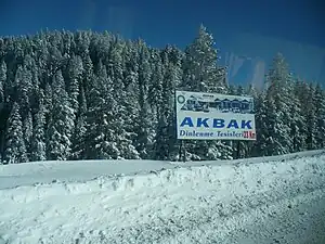
- Fuel: you may use more than you expect on these roads. There's a filling station with charging point by the D765 / E80 junction at Akbak Hotel.
- Self-catering: stock up in a big city supermarket before setting out. Even Ilgaz town doesn't have much retail.
Eat & drink
Hotel restaurants are the best bet. These resorts are too small for free-standing eating places.
Sleep
- 🌍 Jura Ilgaz Mountain Resort, Ilgaz Dağı Milli Parkı, ☏ +90 366 239 1019. Large comfy resort complex right by the ski lifts. B&B double 4000 TL.
- 🌍 Derbent Hotel, ☏ +90 376 417 2020. Pleasant old-fashioned hotel near the road summit.
- 🌍 Ilgaz Nolana Mountain Resort, Yıldıztepe, ☏ +90 376 213 3323. Comfy hotel by the Yıldıztepe ski lifts. B&B double 3500 TL.
- Akbak Otel is near Ilgiz town by the junction of D765 and E80. It's sometimes clean.
- Olgassys Butik Otel is 3 km west of the junction on E80, similarly grubby.
Connect
As of Dec 2024, the mountain resorts and approach highway from the south have 4G from Türk Telekom, but nothing from Turkcell or Vodafone. There's a signal from all carriers on D765 further down the valleys but nothing in the tunnel. 5G has not yet rolled out in Turkey.
Stay safe
Usual precautions about suitable clothing and footwear for the mountains, careful driving on slippy roads, and don't leave valuables on display in your parked car.
Go next
| Routes through Ilgaz National Park |
| Ends at |
N |
→ Junction |