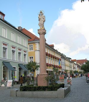
Murnau
Murnau is a city of 12,000 people (2021) in Upper Bavaria about 90 km south of Munich. It is situated on the Staffelsee (lake), just north of the Bavarian Alps.
Understand

Murnau developed in the 12th century out of the Murnau castle.
Directly to its west is the Staffelsee lake and to the south are the peaks and ridges of the Ammergau Alps beginning with the Hörnle and extending up to the Ettaler Manndl, southwest of the Wetterstein. This mountain range is formed by the Zugspitze and the Alpspitze in the south as well as the Estergebirge with their striking Kistenkar and the Walchensee mountains including Heimgarten and Herzogstand in the southeast. To the south, the Murnauer Moos is the largest continuous wetland of its kind in Central Europe.
Tourist information
- Tourist-Information Murnau, Kohlgruber Straße 1, ☏ +49 41-61 41-0, [email protected].
- Murnau City Council website
Get in
Murnau is about 70 kilometres (43 mi) south of Munich.
By train
Murnau is on the train line between Munich and Garmisch-Partenkirchen, and on the Oberammergau train line. Murnau is about an hour's train ride from Munich and half an hour from Garmisch-Partenkirchen.
By car
The A95 motorway and the B 2 Bundesstrasse run through or near Murnau.
Get around
See
- 🌍 Schlossmuseum Murnau, Schloßhof 4-5, ☏ +49 8841 476201, [email protected]. Tu-Su 10:00-17:00.
- 🌍 Münter-Haus, Kottmüllerallee 6. Tu-Su 14:00-17:00. Artists Gabriele Münter and Wassily Kandinsky lived there during the summer months from 1909 to 1914.
Do
- Take a boat ride on the Staffelsee. The Staffelsee is a scenic lake with a number of islands. Boat trips aboard the comfortable MS Seehausen call at Seehausen, Achele (Murnau) and Uffing. €9.50 for the full round trip.
- Take a walk. The Das Blaue Land walking map (in German), available from the visitor centre in Murnau, shows the following routes:
- Staffelsee-Rundweg (20.5 km) – full circumnavigation of the Staffelsee; can be shortened by incorporating a Staffelsee boat trip (above)
- Schwaigrohr-Rundweg (4 km) – from Grafenaschau
- Loisach-Rundweg (8 km) – from Großweil
- Drachenstich-Rundweg (5.8 km)
- Moos-Rundweg (12.5 km) – explores the Murnauer Moos, a marshland nature reserve
- Kleine Staffelsee-Schlife (5.3 km) – a short lakeside stroll from Uffing
- Guglhör-Rundweg (11.5 km)
- Höhlmühle-Rundweg (5.8 km)
- Riegsee-Rundweg (9 km) – circumnavigation of the Riegsee, a smaller lake than the Staffelsee
- Weiler-Rundweg (7.5 km) – from Großweil
- Tafertshofen-Rundweg (15.4 km) – from Schöffau
- Kirnberg-Rundweg (8.4 km) – from Schöffau
- Hungerbach-Rundweg (9.3 km)
- Schwaiganger-Rundweg (6.4 km)
For a map covering the wider area, buy the Pfaffenwinkel Ammergauer Alpen nördl. Teil (UK50-49) map (scale 1:50000). Unfortunately the excellent Deutscher Alpenverein maps (scale 1:25000) do not extend this far north, though the Ammergebirge Ost (sheet BY 7) and Estergebirge (BY 9) sheets cover the mountain areas to the southwest and south respectively.
Buy
Eat
- 🌍 Krönner, Obermarkt 8, ☏ +49 8841 1272.
Drink
- Griesbräu, Obermarkt 37 (In the pedestrian zone), ☏ +49 8841 1422, [email protected]. A private brewery whose delicious beer is only sold onsite. (It's also a restaurant and hotel.)
Sleep
- Hotel Angerbräu, Untermarkt 44 (Just south of the pedestrian zone), ☏ +49 8841 625876, [email protected]. €92 single room.
Connect
Go next