Valle del Jerte
Valle del Jerte is a rural area east of Plasencia, Spain. It is on the eastern boundary of Extremadura with Castile and Leon.
Understand
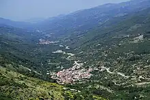
Restaurants, hotels, and hiking areas are found in both the villages and the agricultural parts of the valley. A reservoir to the southwest, mountain ranges to the north and south, and a mountain pass in the northeast mark the boundaries of Valle del Jerte.
There are several villages in the valley. Some of the largest villages from southwest to northeast include:
Get in
The highway N-110 connects the villages across the region with Castile and Leon (to the northeast) and Plasencia (to the southwest). As a result you will want a car to navigate this region but there are bus and train networks in nearby Plasencia.
Get around
By car
The best way to navigate this valley is via car, given its rural nature and minor/private roads leading to accommodation and points of interest.
See
- 🌍 Calvitero. A mountain of the Sistema Central, to the north of the valley, at a height of 2,400 m (7,900 ft).
- 🌍 Puente Nuevo de Carlos V. Bridge on the Route of Carlos V dating back to the 16th century.
- 🌍 , N-110 (if traveling northeast, parking is available via a turn to the right). Mountain pass to Castile and Leon at a height of 1,275 m (4,183 ft).
Do
- 🌍 Garganta de los Infiernos, N-110, Km 368, ☏ +34 927 014 936, [email protected]. A nature reserve in the far west of the Sierra de Gredos, with an area of 7000 hectares. The 🌍 Nature Reserve Visitor Center is at the entrance to the park with parking available.
Buy
Eat
- 🌍 El Castillo, N-110, Km 368, 5, Cabezuela del Valle, ☏ +34 927 492 379, [email protected]. Traditional cuisine with a varied menu.
- 🌍 Garza Real, C/ Piscinas, 12, Valdastillas, ☏ +34 626 982 784. Restaurant with rentals available.
Drink
Sleep
- 🌍 Alameda del Jerte, Ctra. de El Torno, km 6, ☏ +34 656 866 424, [email protected]. Rural apartments surrounded by farms and the Rio Jerte.
- 🌍 Casa Valeriana, Paraje Nogaledas, Navaconcejo, ☏ +34 644 255 025, [email protected]. Tourist apartments in the hills north of Navaconcejo.
- 🌍 Casas Rurales en el Jerte, Paraje El Tumba, ☏ +34 607 497 961. Rural tourist properties available for booking. East of Navaconcejo.
- 🌍 Hotel Balneario, Carretera Nacional 110, Km 383, ☏ +34 927 633 000, [email protected]. Rural villa with restaurant, cafeteria, and buffet.
Go next
- Continuing to follow N-110 to the northeast across the pass will lead you into Castile and Leon.
- Following N-110 to the southwest will lead you to Plasencia.