I’m glad I could find some other people on the internet that have these kind of ideas as well. I am also in no way qualified within the field of civil engineering just interested in this specific topic, so please feel free to correct me.
My first thoughts upon this idea was to have “units” as such. Because of the hexagons unique properties to tile so well, and its tendency to make effectively “upscale” (see examples below to see what I mean) I thought it was perfect.
The idea of having modules, or districts as my friend calls, them seemed also very appealing
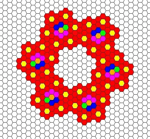
Here is the proposed model for a base unit. For future reference here is a key of what colours will represent:
Red - Housing
Yellow - Local community. Everything a person would need within walking distance (food stores, transport centres, gymnasiums etc.)
This same design can be scaled up to accommodate more needs that only need to be within a small journey( more of that explained later down the post)
Orange - Transport hub
Blue - Medical/ general practitioners
Green - School
Pink - Shops and other services
The same applies to more scaled up versions

I would love some input into what needs to be included here
As mentioned before this design is ideally supposed to be a car free area. Trains lines would run from yellow centres to orange centres and orange centres into the centre of the larger upscale (incomplete), and into other orange centres, making for a more time and energy efficient journey. This would allow for every single person to be within a maximum distance from a service, and the distance to be reasonable (e.g a 5-10 minute to commute to school)
I am still aware that this design is highly impractical for real life use and there lie flaws within it, but I would appreciate any feedback people would be able to help me further develop this concept

